Environmental footprint of diffuse emissions in European Functional Urban Areas
Sustainable Development [n/a], [n/a] (February 2026)
https://doi.org/10.1002/sd.70780
In this paper we quantify the environmental footprint of diffuse air emissions across 776 European Functional Urban Areas (FUAs) from 2005\u20132022 by coupling Copernicus Atmosphere Monitoring Service (CAMS) gridded inventories with the Environmental Footprint (EF) 3.1 framework.
CAMS emissions are harmonised into twelve GNFR sectors and nine pollutants, spatially allocated by GIS overlays to FUAs and surrounding territories using a largest-overlap rule to obtain an explicit In/Out FUA split, and translated into EF 3.1 impacts through characterisation. Impacts are aggregated into a policy-ready Weighted and Normalised Footprint Indicator (WENFIn) using EF 3.1 normalisation and weighting, with intensity (WENFId) and per-capita (WENFIcap) derivatives. Results show an overall ~25% decline with a 2020 trough, a broadly stable In/Out FUA balance, urban burdens dominated by fossil CO2 and PM2.5, and non-urban burdens dominated by NH3 and CH4. Clustering of EF profiles identifies four robust FUA archetypes, supporting differentiated, just mitigation portfolios.
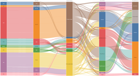
All visualizations related to the data used in this article can be accessed from Visualizations.